

Using drones allows volumetric surveys to be completed in a fraction of the time of conventional survey methods leading to lower costs, higher productivity and improved safety
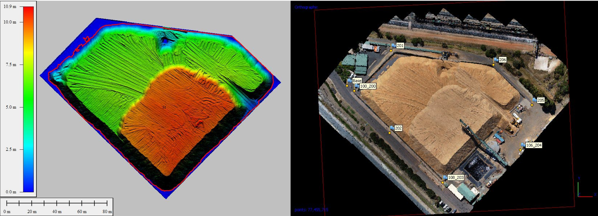
“Digital Elevation Model (left) produced from imagery (right) and photogrammetry processing”
.
Bunbury Fibre Exports is an Australian company that provides harvesting, transport, processing, exporting and plantation management services to the plantation timber industry in the South West of Western Australia.
The company maintains and manages a state-of-the-art wood processing and export facility at the Port of Bunbury. All of the company’s timber is processed at the facility in preparation for export to the company’s international markets.
As part of its planning and financial compliance requirements, Bunbury Fibre Exports is required to undertake a volumetric survey of its stockpile at the Port of Bunbury on an annual basis. An accurate stockpile assessment is also required to support its ongoing inventory management processes.
In the past, like most stockpile assessments, the stockpile volumes have been calculated from traditional real-time kinetic surveys, requiring surveyors to climb over stockpiles taking a number of spot measurements with conventional GPS equipment. However, this method can be slow, costly and inaccurate due to the limited number of sampling points and the inference of heights between sometimes sparse points. Further, climbing over stockpiles can be physically demanding and hazardous for survey crews and injuries such as sprains and strains have been common.
![]()
Terra Drone Australia now undertakes the annual stockpile survey using a multirotor drone. The drone fitted with a multiband GNSS and a calibrated camera is used to take hundreds of downward looking images across the stockpile. A dense point cloud is computed from the image data using Agisoft Photoscan photogrammetry software. The point cloud is then cleansed of above ground features (conveyors) and noise using geometric filters, before having a high-resolution surface digital elevation model produced. From here a volume accurate to less than 0.5% can be produced.
Terra Drone Australia Operations Manager added, “This is a real-world example where drones have made a significant improvement to business processes. The vast majority of businesses that stockpile materials such as aggregates or minerals, or in this case wood chips, are now computing volumes from drone surveys”.
Bunbury Fibre Exports Operations Manager Brett Humble said, “Stockpile survey by Terra Drone is fast, safe, accurate and provides others benefits like a 3D model of the stockpile with such detail that you can clearly see the dozer tracks. It is the future.”
It’s estimated that volumetric surveys by drones is up to 60-80% faster than by conventional survey methods.


