

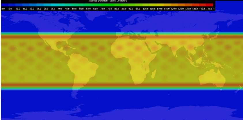
- Increased, higher value data from world’s areas of risk
- Orbit change to 37-degree inclination provides up to 4.5 times more data where most illegal activity occurs including the Strait of Hormuz, South China Sea, and off the North Australia coast, South US coast and East and West African coasts
- Launch provider change to highly reliable PSLV operated by Indian Space Research Organisation
Kleos Space S.A. (ASX: KSS, Frankfurt: KS1), a space-powered Radio Frequency Reconnaissance dataas-a-service (DaaS) company, advises that it has changed launch providers for its Scouting Mission¹ satellites which will now launch into a 37-degree inclination.
The 37-degree orbital inclination gives the Kleos’ Scouting Mission1 cluster of four satellites improved data collection by a factor of between 2 and 4.5 times over crucial shipping target regions such as The Strait of Hormuz, South China Sea, and off the North Australia coast, South US coast and East and West African coasts when compared with the originally planned Sun Synchronous Orbit (SSO).
Following the recent postponement of the launch of Kleos’ Scouting Mission satellites, Kleos investigated other available launch options with launch and mission management provider Spaceflight Inc. that would meet immediate market demand and potentially increase the value of the data collected.
Since the original choice of SSO was made over a year ago, the threat level in the equatorial regions has increased and Kleos has made significant progress in engaging the market and securing defence and security customers who have an interest in these regions, where increased coverage provides better data and improved mission critical information for customers.
Keeping within the Q4 2019 launch window, Kleos will now launch under a rideshare contract with Spaceflight Inc. on the PSLV into a 37-degree inclination orbit.
The scouting satellites are ready to fly. The Kleos team has analysed and confirmed compatibility with the satellites flying in a 37-degree inclination. Unlike most earth observation missions which fly in an SSO to allow for the sun to illuminate their targets for imagery, Kleos technology means its satellites can observe RF transmissions at any time of day because they are not dependant on sunlight.
The Polar Satellite Launch Vehicle (PSLV) is a highly reliable expendable medium-lift launch vehicle designed and operated by the Indian Space Research Organisation (ISRO).
The original SSO is nearly a polar orbit that maintains its relationship with the sun which is useful for power generation and for missions that rely on illumination of the target. SSO gave full global coverage, with good revisit times of the polar areas. PSLV C49 is in a 37-degree inclination, which is where the satellites orbit traverses between 37° North latitude and 37° South latitude. The coverage is broadly bounded by Lisbon in the North and Melbourne in the South delivering far improved revisit times around the equatorial regions at the expense of coverage in the far North and South.
Graphics below show: the potential of data collection by the Scouting satellites in their new orbit the from the key regions of interest with excellent revisit rates when compared with SSO; and global maritime illegal activity/piracy hotspots highlighted in The State of Maritime Piracy 2018 report from One Earth Future.
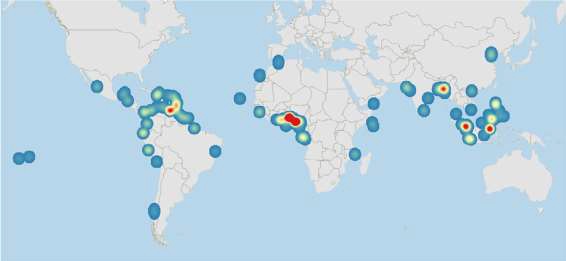
“Source: The State of Maritime Piracy 2018 – One Earth Future”
Kleos’ CEO Andy Bowyer said, “The change in inclination opportunity allows Kleos to deliver more frequent and higher value coverage for a broad spectrum of users – through defence, security and commercial operations in their key areas of interest when compared to Sun Synchronous Orbit.
“When a ship goes dark to vanish from global tracking systems, Kleos satellites can locate them through their RF transmissions.
“In the last month alone, at least 20 ships have switched off their transponders in the Strait of Hormuz to avoid detection. Our customers eagerly await our data.”
¹ The multi-satellite Scouting Mission system will form the foundation of a constellation that delivers a global picture of hidden maritime activity, enhancing the intelligence capability of government and commercial entities when AIS (Automatic Identification System) is defeated, imagery is unclear, or targets are out of patrol range. The first scouting mission is made up of 4x nano-satellites built by GomSpace in Denmark, each the size of a shoebox.